Landing Indicator v0.2.2

![Ford Mustang Mach-E [PACK]](https://temp2.modland.net/i/6aa50a7184eaa/0_modland.webp)
![BMW X6 G06/F96 [PACK]](https://temp2.modland.net/i/6a8ff76445a04/0_modland.webp)

5/5,
1
votes
Description
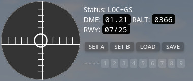
This app adds fixed wing landing aids, simulating an ILS-style setup with a localizer and glideslope. The localizer indicates the runway direction, while the glideslope indicates the required altitude for your current distance.
Features
- Landing indicator with a course deviation indicator, including a localiser for runway alignment and a 3-degree glideslope for final approach
- DME, which indicates the distance to the airport or airfield in nautical miles
- Radio altitude, which indicates altitude above ground level in feet
Configuration
To configure the indicator, set points A and B at the touchdown points at each end of the runway. You can use either the current vehicle position or freecam to set these points. If you use freecam, place the camera at about half the vehicle's height so the point matches the center of the vehicle.
Save and load
You can save and load configurations so you do not need to set them again every time.
- To save a config, click SAVE and then choose a slot from 1 to 9
- To load a config, click LOAD and then select the same slot
- Each map or level has nine save slots
- Saved data is stored as a JSON file in the BeamNG.drive user folder at: user_folder/settings/ui_apps/aviator331/landingIndicator.json
- If you click SAVE or LOAD by mistake, click the same button again to cancel
Status reference
- UNSET: neither point has been set
- SET A: point A has not been set
- SET B: point B has not been set
- IDLE: both points are set, but nothing has been intercepted yet
- LOC: the localizer has been intercepted
- GS: the glideslope has been intercepted
- LOC+GS: both the localizer and glideslope have been intercepted
Course deviation indicator
The circle on the left is the course deviation indicator. It shows two needles:
- Vertical needle: Localizer
- Horizontal needle: Glideslope
When the localizer needle is centered, you are aligned with the runway centerline in terms of position, not heading.
- If the needle is offset to the right, you are left of the runway and should move right
- If the needle is offset to the left, you are right of the runway and should move left
When the glideslope needle is centered, you are descending along the correct glide path.
- If the needle is shifted upward, you are below the glideslope and should reduce your descent
- If the needle is shifted downward, you are above the glideslope and should increase your descent
Other readings
- DME shows the distance to the runway center point, halfway between points A and B, in nautical miles. This is a slant distance, so it includes altitude difference as well as horizontal distance.
- RALT shows radio altitude, which is the distance straight down to the ground in feet. The maximum reading is 2500.
- RWY shows the automatically generated runway number for the current setup. It is based on the runway heading in whole degrees with the last digit removed. The opposite direction is then calculated by adding or subtracting 180 degrees. The lower number is shown first. 0 is never used, and 36 is used instead.
Basics
You should always try to capture the localizer first and center it. After that, capture the glideslope from below, not from above.
Details
- The localizer range is 18 nautical miles within 10 degrees of the centerline
- The localizer range is 10 nautical miles within 35 degrees of the centerline
- Full deflection of the localizer needle happens at 2.5 degrees or more off center in either direction
- Full deflection of the glideslope needle happens at 0.7 degrees or more off center in either direction
- The glideslope follows a 3-degree descent path to 0 ft at the exact position of point A or B
- The glideslope is disabled below 50 ft AGL
- Capturing the glideslope from below is the correct procedure
This app adds fixed wing landing aids, simulating an ILS-style setup with a localizer and glideslope. The localizer indicates the runway direction, while the glideslope indicates the required altitude for your current distance.
Features
- Landing indicator with a course deviation indicator, including a localiser for runway alignment and a 3-degree glideslope for final approach
- DME, which indicates the distance to the airport or airfield in nautical miles
- Radio altitude, which indicates altitude above ground level in feet
Configuration
To configure the indicator, set points A and B at the touchdown points at each end of the runway. You can use either the current vehicle position or freecam to set these points. If you use freecam, place the camera at about half the vehicle's height so the point matches the center of the vehicle.
Save and load
You can save and load configurations so you do not need to set them again every time.
- To save a config, click SAVE and then choose a slot from 1 to 9
- To load a config, click LOAD and then select the same slot
- Each map or level has nine save slots
- Saved data is stored as a JSON file in the BeamNG.drive user folder at: user_folder/settings/ui_apps/aviator331/landingIndicator.json
- If you click SAVE or LOAD by mistake, click the same button again to cancel
Status reference
- UNSET: neither point has been set
- SET A: point A has not been set
- SET B: point B has not been set
- IDLE: both points are set, but nothing has been intercepted yet
- LOC: the localizer has been intercepted
- GS: the glideslope has been intercepted
- LOC+GS: both the localizer and glideslope have been intercepted
Course deviation indicator
The circle on the left is the course deviation indicator. It shows two needles:
- Vertical needle: Localizer
- Horizontal needle: Glideslope
When the localizer needle is centered, you are aligned with the runway centerline in terms of position, not heading.
- If the needle is offset to the right, you are left of the runway and should move right
- If the needle is offset to the left, you are right of the runway and should move left
When the glideslope needle is centered, you are descending along the correct glide path.
- If the needle is shifted upward, you are below the glideslope and should reduce your descent
- If the needle is shifted downward, you are above the glideslope and should increase your descent
Other readings
- DME shows the distance to the runway center point, halfway between points A and B, in nautical miles. This is a slant distance, so it includes altitude difference as well as horizontal distance.
- RALT shows radio altitude, which is the distance straight down to the ground in feet. The maximum reading is 2500.
- RWY shows the automatically generated runway number for the current setup. It is based on the runway heading in whole degrees with the last digit removed. The opposite direction is then calculated by adding or subtracting 180 degrees. The lower number is shown first. 0 is never used, and 36 is used instead.
Basics
You should always try to capture the localizer first and center it. After that, capture the glideslope from below, not from above.
Details
- The localizer range is 18 nautical miles within 10 degrees of the centerline
- The localizer range is 10 nautical miles within 35 degrees of the centerline
- Full deflection of the localizer needle happens at 2.5 degrees or more off center in either direction
- Full deflection of the glideslope needle happens at 0.7 degrees or more off center in either direction
- The glideslope follows a 3-degree descent path to 0 ft at the exact position of point A or B
- The glideslope is disabled below 50 ft AGL
- Capturing the glideslope from below is the correct procedure
External Download Links:
- Modsfire.com - landingindicator.zip [114.23 KB]
Direct Download Links
About Mod
| Latest Version | v0.2.2 |
| Game | BeamNG.drive |
| Category | Other |
| Game Version | 0.39.x |
| Downloads | 41 |
| Created | 1 month ago |
You Might Also Like »

![Ford Mustang Mach-E [PACK]](https://temp2.modland.net/i/6aa50a7184eaa/0_modland.jpg)
![BMW X6 G06/F96 [PACK]](https://temp2.modland.net/i/6a8ff76445a04/0_modland.jpg)





0 Comments
There are no comments. Be first to comment!