Tyrolean Whitecreek Valley 1.0

0/5,
0
votes
Description:
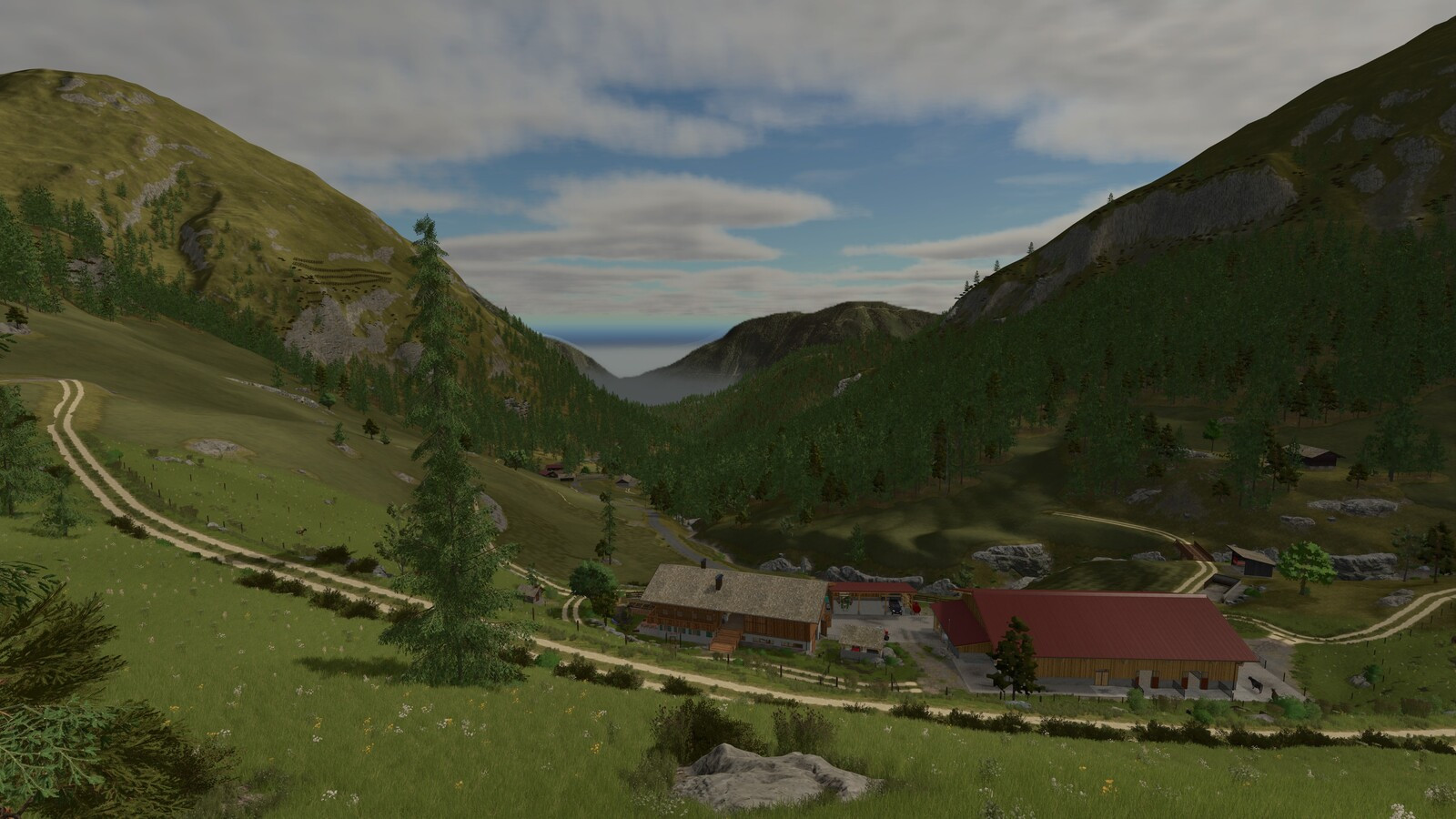
Welcome to a mountain farm at 1607m above sea level, right in the middle of the Northern Tyrolean Alps. This map is based on real terrain and authentic elevation data from the Weißenbachtal. The buildings and farms are inspired by various valleys in Tyrol.
The map features two mountain farms: Obertalerhof, which offers barns for cows and goats/sheep, several shelters, a hay barn, and a modern hay drying facility with a hay crane; and Oberhaberlhof, a small timber operation with its own sawmill and a chicken coop.
You will find a cheese dairy as a selling point for milk or for producing your own cheese. A mountain inn with a shop serves as an additional selling point. A standard vehicle fleet is available, and a small dealer allows you to expand your equipment. The barns are not empty: cows and goats are already waiting for their feed. If you want to buy or sell animals, a small livestock dealer is located right next to the main dealer. Wood and woodchips can be traded at a dedicated wood buyer.
Steep meadows are part of everyday life here – you will need courage and the right machinery to safely harvest your hay. The region is purely grassland farming due to the high altitude, however, a field has been added where you can try your luck. Besides haymaking, forestry plays an important role with challenging and varied forest areas.
Features:
- Real terrain based on elevation data from Tyrol
- Strongly increased terrain scaling for a true alpine landscape
- Mountain farm with cow barn and goat/sheep barn
- Own hay crane
- Grassland farming with steep meadows
- Custom buildings
- Custom decorative objects such as avalanche barriers
- Seasonal objects like snow poles
- Mountain stream with flowmap
- Custom tree species such as mountain pine (Latschen)
- Improved foliage (realistic selection of meadow plants) and correct scaling of cut grass
- Adjusted feeding system
- Adjusted climate according to altitude (snow possible in spring and autumn)
- Adjusted map lighting
- Adjusted crop types suitable for high-altitude farming
- Custom license plates fitting Austria/Tyrol
Credits:
tirolerHeimahd modding
Welcome to a mountain farm at 1607m above sea level, right in the middle of the Northern Tyrolean Alps. This map is based on real terrain and authentic elevation data from the Weißenbachtal. The buildings and farms are inspired by various valleys in Tyrol.
The map features two mountain farms: Obertalerhof, which offers barns for cows and goats/sheep, several shelters, a hay barn, and a modern hay drying facility with a hay crane; and Oberhaberlhof, a small timber operation with its own sawmill and a chicken coop.
You will find a cheese dairy as a selling point for milk or for producing your own cheese. A mountain inn with a shop serves as an additional selling point. A standard vehicle fleet is available, and a small dealer allows you to expand your equipment. The barns are not empty: cows and goats are already waiting for their feed. If you want to buy or sell animals, a small livestock dealer is located right next to the main dealer. Wood and woodchips can be traded at a dedicated wood buyer.
Steep meadows are part of everyday life here – you will need courage and the right machinery to safely harvest your hay. The region is purely grassland farming due to the high altitude, however, a field has been added where you can try your luck. Besides haymaking, forestry plays an important role with challenging and varied forest areas.
Features:
- Real terrain based on elevation data from Tyrol
- Strongly increased terrain scaling for a true alpine landscape
- Mountain farm with cow barn and goat/sheep barn
- Own hay crane
- Grassland farming with steep meadows
- Custom buildings
- Custom decorative objects such as avalanche barriers
- Seasonal objects like snow poles
- Mountain stream with flowmap
- Custom tree species such as mountain pine (Latschen)
- Improved foliage (realistic selection of meadow plants) and correct scaling of cut grass
- Adjusted feeding system
- Adjusted climate according to altitude (snow possible in spring and autumn)
- Adjusted map lighting
- Adjusted crop types suitable for high-altitude farming
- Custom license plates fitting Austria/Tyrol
Credits:
tirolerHeimahd modding
Direct Download Links
Version: 1.0Updated: 1 week ago
Total Size: 807.27 MB FS25_TyroleanWhitecreekValley_modland.zip direct download · 807.27 MB · added 1 week ago
You Might Also Like »
0 Comments
There are no comments. Be first to comment!